
Maps and Project-Impact Reports
 In order to apply for this construction project, DB5 Development Group performed analysis of the land, environment, and neighborhood.
According to DB5 Development, existing public utilities servicing the property include public sewer, public water (from the Town of Reading), electricity, cable TV, telephone, and other communication lines. There are no anticipated adverse impacts relative to public services or utilities to abutting properties or to the Town in general.
DB5 Development states that there are no wetland resource areas or flood hazard areas affecting the property. Tarrant Lane does not have any significant historic or archeological features, nor is protected by the Town of Wakefield Historic Structures Bylaw.
No portion of the property is within any protected priority habitat or estimated habitat for species protected by the Natural Heritage and Endangered Species Program and there are no certified vernal pools on or in the vicinity of the property. This stormwater management system has been designed to meet Massachusetts Department of Environmental Protection (MassDEP) Stormwater Management Standards. DB5 Development Group’s traffic study concluded that the project will have no adverse impact on public safety nor any significant traffic impacts to the surrounding roadway system.
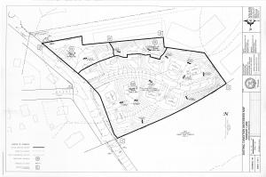
Maps and project impact documentation:
Note that many of these documents are large and may take a few moments to download.
- Clearance that Tarrant Lane is not a registered historical site
- Flood maps
- Neighborhood and property site photos
- Species map
- Stormwater report
- Town of Reading water use letter from Town Manager Robert W. LeLacheur
- Traffic analysis and report
- Vernal pools map
- Wetlands map